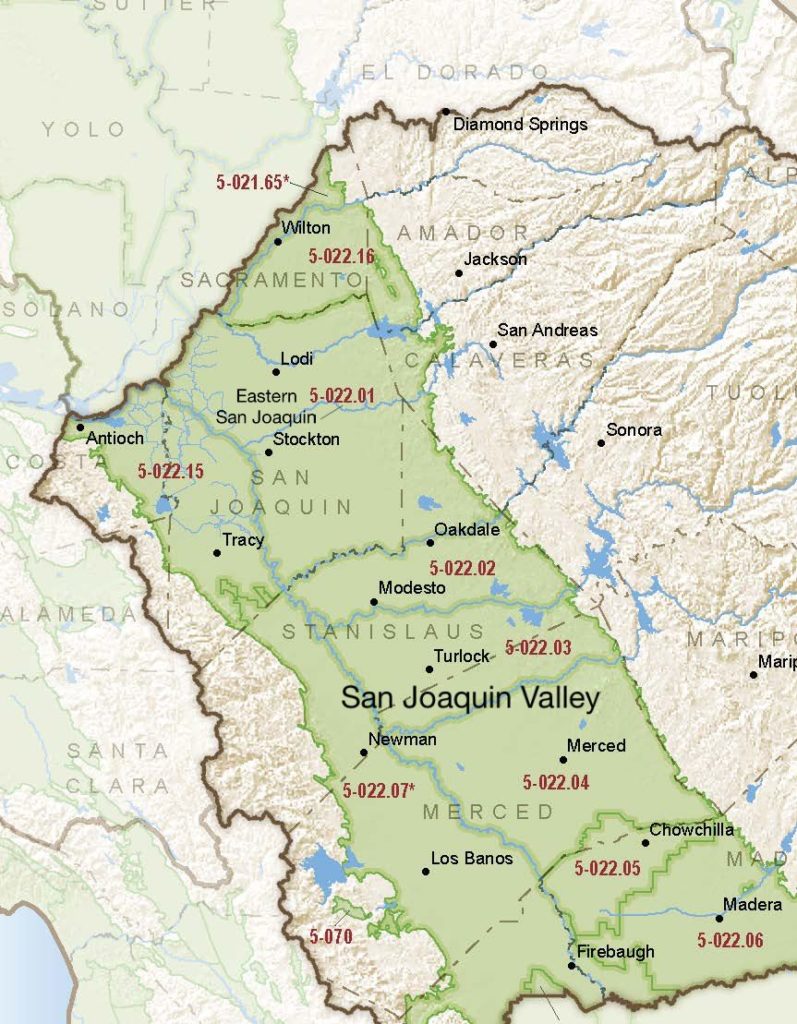
San Joaquin Valley – Eastern San Joaquin
Statistics
- Basin Name
- San Joaquin Valley – Eastern San Joaquin
- Basin Number
- 5-022.01
- SGMA Basin Priority
- High
- Critically Overdrafted
- Yes
- Hydrologic Region Name
- San Joaquin River
- Counties
- Calaveras, San Joaquin, Stanislaus
At-A-Glance
Located in California’s San Joaquin hydrologic region, the San Joaquin Valley – Eastern San Joaquin subbasin is 764,802.78 acres in size. This High priority basin is home to an estimated 573,142 people (2010 value). It has approximately 13668 wells, of which approximately 415 are water supply wells. Groundwater accounts for approximately 35 percent of the basin’s water supply.

Basin Notes
2003: Bulletin 118 basin description
2014: CASGEM basin prioritization – high. Comments: Estimated that 70,000 af/year of overdraft occurs in northeastern San Joaquin County and about 35,000 af/year of overdraft occurs in the Stockton East Water District (B‐118) & (USBR 1996). Basin experiencing long term GW overdraft 160,000AF/yr (local GWMP). From B118: as a result of overdraft poor quality groundwater has been moving east along a 16‐mile front on the east side of the Delta and has continued to migrate eastward (USACE 2001). Large areas of nitrate contamination are located in the subbasin.
2016: Basin boundary modification approved with Cosumnes 5-022.16 subbasin
Revised basin boundaries description
2018: Basin priority – high. Declining groundwater level and salt intrusion comments:
- CRITICAL OVERDRAFT. Source: DWR 1) CASGEM/WDL/GWIDS: Longterm hydrographs show groundwater level decline. Source: DWR 2) The plan also must address whether and how placing water to underground storage and subsequently withdrawing the water, under Permit 10477 will prevent additional overdraft in the Eastern San Joaquin and Cosumnes groundwater subbasins and include measures to avoid any such impacts. Source: North San Joaquin Water Conservation District Conjunctive Use Plan Water levels are declining and chloride concentrations are increasing in western San Joaquin County as a result of pumping in excess of recharge. Source: San Joaquin Chlorides – supplementary drilling Stockton East Water District, U.S. Geological Survey (USGS).
- 1) In the Eastern San Joaquin subbasin, the groundwater is characterized with low to high salinity levels and localized areas of high calcium or magnesium bicarbonate, salinity, nitrates, pesticides, and organic constituents (DWR 2006j, 2013b). The high groundwater salinity is attributed to poor-quality groundwater intrusion from the Delta caused by the pumping-induced decline in groundwater levels, especially in the groundwater underlying the Stockton area since the 1970s (San Joaquin County Flood Control and Water Conservation District 2008). (pg. 7-34) The east side of the San Joaquin River is underlain by seven groundwater subbasins: the Cosumnes, Eastern San Joaquin, Modesto, Turlock, Merced, Chowchilla, and Madera subbasins. Declining groundwater levels in the subbasins east of the San Joaquin River have resulted in an area approximately 16-miles long with high salinity due to saltwater intrusion from the Delta (USFWS 2012). Doesn’t say along which 16-mile stretch of which sub-basin (Cosmunes, East San Joaquin, Modesto, Turlock, Merced, Chochilla, Madera). (pgs. 7-32, 7-33) Source: Coordinated Long Term Operation of the Central Valley Project, EIS, US Bureau of Reclamation, Chapter Seven. 2) In the Eastern San Joaquin Groundwater Subbasin, near Stockton, California, 130 km east of San Francisco (Fig. 1), pumping in excess of recharge and resulting declines in water levels within aquifers to below sea level has led to an increase in chloride concentrations in water from wells (Izbicki et al. 2006). This trend began in the 1950s and has led to exceedances of the US EPA secondary maximum contaminant level (SMCL) of 250 mg/L for chloride in several wells (DWR 1967). In an effort to mitigate the impact of high-chloride water on groundwater supplies, local agencies, led by the Eastern San Joaquin County Groundwater Basin Authority in cooperation with the DWR, Stockton East Water District, and the City of Stockton, implemented strategies involving the conjunctive use of surface water and groundwater to meet demand. Artificial recharge programs have also been implemented that promote infiltration of captured local runoff to manage declining water levels and chloride concentrations. Programs include Stockton East Water District’s Farmington Groundwater Recharge Program, with a goal of recharging about 43,106 m3 /year annually through field-flooding (Stockton East Water District 2014) and the City of Stockton’s Morada Recharge Facility, which utilizes an existing stormflow basin to infiltrate local surface water and stormflow runoff (OLeary et al. 2012). Source: Sources of high-chloride water and managed aquifer recharge in an alluvial aquifer in California, USA, Hydrogeology, 2015
2019: Basin boundary modification. Per DWR: “This basin boundary modification revises the Eastern San Joaquin and Tracy subbasin boundaries to align with the City of Lathrop’s city limits. The modification places the City of Lathrop entirely within the Tracy subbasin.” November – Groundwater Sustainability Plan published
2020: January 29 – GSP submitted to DWR.
2022: January 28 – DWR deems the GSP “incomplete,” stating it “has not defined sustainable management criteria (SMC) for the chronic lowering of groundwater levels” and “does not provide enough information to support the use of the chronic lowering of groundwater level SMCs and representative monitoring network as a proxy for land subsidence.”
July 27 – GSA re-submits revised GSP
2023: July 6 – Revised GSP approved by DWR
