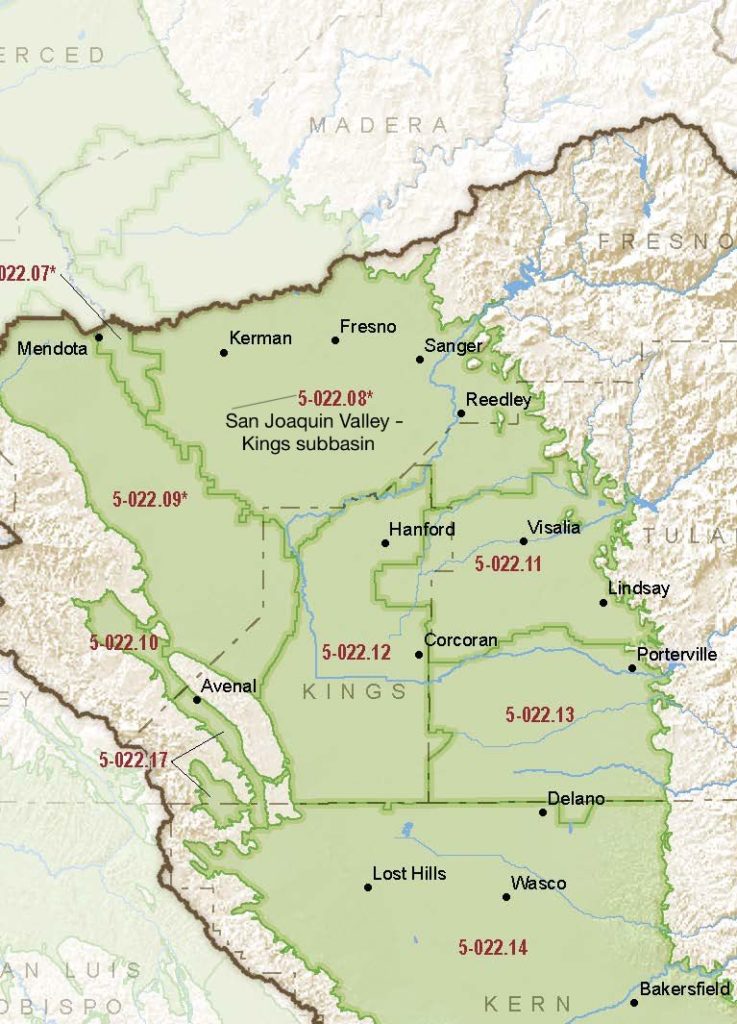
San Joaquin Valley – Kings
Statistics
- Basin Name
- San Joaquin Valley – Kings
- Basin Number
- 5-022.08
- SGMA Basin Priority
- High
- Critically Overdrafted
- Yes
- Hydrologic Region Name
- Tulare Lake
- Counties
- Fresno, Kings
At-A-Glance
Located in California’s Tulare Lake hydrologic region, the San Joaquin Valley – Kings subbasin is 981,324.82 acres in size. This High priority basin is home to an estimated 916,084 people (2010 value). It has approximately 17 wells, of which approximately 698 are water supply wells. Groundwater accounts for approximately 84 percent of the basin’s water supply.

Basin Notes
2003: Bulletin 118 basin description
2014: CASGEM basin prioritization – high
2016: Basin boundary modifications approved with the Madera 5-022.06, Westside 5-022.09, Delta-Mendota 5-022.07, and Tracy 5-022.15 sub-basins
2018: Draft priority – high. Groundwater level and salt intrusion comments:
- CRITICAL OVERDRAFT 1) CASGEM/WDL/GWIDS: Longterm hydrographs show groundwater level decline. Source: DWR 2) The region faces many water management challenges including groundwater overdraft, surface water shortages in dry years, and groundwater quality problems in certain areas. Groundwater overdraft is generally considered the largest regional problem with the current plan area overdraft estimated to be 100,000 to 150,000 AF/year. The longterm decline in groundwater storage will be significant if current water management strategies are maintained. Correcting the overdraft through regional efforts will help lead to overall maintenance and improvement in the quantity, quality and cost of development of groundwater resources in the region.
- Sources: 1) Current Land Subsidence in the San Joaquin Valley, USGS; 2) 2014 – Land Subsidence from Groundwater Use in California, California Water Foundation / James W. Borchers / Michael Carpenter, Luhdorff & Salmanini, April 2014; 3) Progress Report: Subsidence in the Central Valley, California, Jet Propulsion Laboratory, California Institute of Technology, NASA 2015-16
Shallow Aquifers of the Madera– Chowchilla and Kings Subbasins, San Joaquin Valley, California, U.S. Geological Survey, January 2018
2019: Basin boundary modification. Per DWR: It “revises the northeastern external boundary of the Kings subbasin to more accurately follow mapped contacts between alluvial units and non- alluvial geologic units. The requesting agency provided sufficient scientific rationale and utilized a qualified map for the boundary revision.” Phase 2 draft basin priority: high December 20, 2019 – Coordination agreement between Central Kings, Kings River East, North Fork Kings, James Groundwater, North Kings and South Kings GSAs
2020: January 28th –
- Central Kings GSA Groundwater Sustainability Plan (GSP) submitted to the Department of Water Resources
- North Fork Kings GSP submitted to DWR
- South Kings GSA‘s GSP submitted to DWR
- McMullin Area GSA‘s GSP submitted to DWR
- Kings River East GSP submitted to DWR
- North Kings GSP submitted to DWR
- James GSA GSP submitted to DWR
2021: December 9 – DWR writes collective GSAs warning that preliminary review of the GSPs spotted deficiencies that will need addressing
2022: Subbasin GSAs collectively notified that their GSPs are “incomplete” because of failure to to set satisfactory sustainable management criteria for chronic lowering of groundwater levels, subsidence avoidance, damage to interconnected surface waters and impacts on water quality. The seven cooperating GSAs given until July 27, 2022 to submit revised GSPs
July 14 – North Fork Kings approves revised GSP.
July 22 – James GSA submits a revised GSP. No signature by preparing engineer.
July 27 – Revised North Fork Kings GSP submitted to DWR.
July 27 – Revised Central Kings GSP submitted to DWR.
July 28 – Kings River East revised GSP submitted to DWR.
2023: August 4 — GSPs approved by DWR
