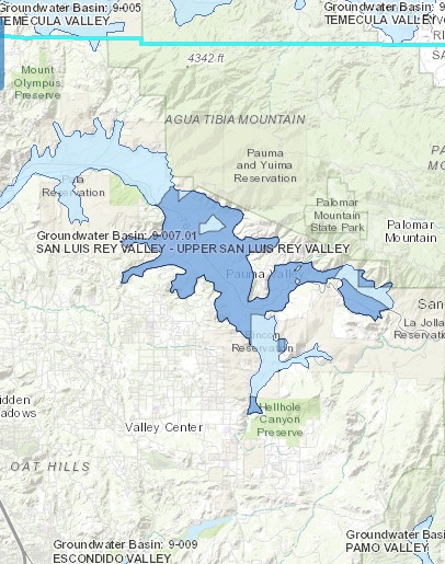
Upper San Luis Rey Valley (formerly San Luis Rey Valley)
Statistics
- Basin Name
- Upper San Luis Rey Valley (formerly San Luis Rey Valley)
- Basin Number
- 9-007.01
- SGMA Basin Priority
- Medium
- Critically Overdrafted
- No
- Hydrologic Region Name
- South Coast
- Counties
- San Diego
- Adjacent Basins
At-A-Glance
Located in California’s South Coast hydrologic region, the Upper San Luis Rey Valley (formerly San Luis Rey Valley) is 19,254.35 acres in size. This Medium priority basin is home to an estimated 3,743 people (2010 value). It has approximately 56 are water supply wells. Groundwater accounts for approximately 70 percent of the basin’s water supply.

Basin Notes
1988: San Luis Rey Indian Water Rights Settlement Act
2003: Bulletin 118 basin description
2013: San Diego County Integrated Regional Water Plan – tribal nations
2016: Basin boundary modification request denied. Per DWR: The request did not provide sufficient scientific information demonstrating a hydrogeologic barrier preventing groundwater flow Revised basin boundary description
2018: Draft basin priority – Medium. Comments:
- Salt intrusion: 1) The groundwater is characterized as calcium-sodium bicarbonate-sulfate with localized areas of high magnesium, nitrate, and TDS (MWDSC 2007). Reduced groundwater pumping allowed groundwater levels to recover to historical levels, which also reduced effects associated with seawater intrusion. Source: Coordinated Long-Term Operation of the Central Valley Project and State Water Project, EIS, US Bureau of Reclamation, Chapter7
- 2) Groundwater use in the San Luis Rey Valley Groundwater Basin peaked in the 1950s and 1960s, resulting in drastic declines in groundwater water levels due to groundwater development and over-pumping (leading to seawater intrusion that extended between two and six miles inland from the Pacific Coast). Delivery of imported water into the San Luis Rey Valley Groundwater Basin began after completion of the first San Diego Aqueduct in 1947; the introduction of imported water into the basin led to reduced groundwater pumping, which over time, has reduced groundwater pumping and allowed groundwater levels to recover to historical levels. Water importation has also reduced impacts associated with seawater intrusion. As it sits at the terminus of the San Luis Rey Valley Groundwater Basin and is therefore the first to be impacted by seawater intrusion, the City of Oceanside has actively pursued groundwater sustainability in the proposed Mission Sub-basin in order to protect an important part of its water supply system. The City has used a combination of imported surface water and recycled water to offset groundwater demands, and closely monitors both groundwater levels and quality to ensure the continued sustainability of this supply. Source: San Luis Rey Valley Basin Boundary Modification (Section G)
Noted: Assembly Bill No. 1944
2019: Basin boundary modification: San Luis Rey Valley 9-007 split into two subbasins, Upper and Lower San Luis Rey valleys, 9007-01 and 02.
Upper San Luis Rey Valley phase 2 draft priority: Medium.
