
The Sustainable Groundwater Management Act (SGMA) requires that a Groundwater Sustainability Agency prepare a Groundwater Sustainability Plan that lays out the path that the basin will take to achieve sustainable groundwater management within 20 years. The path for preparing a Groundwater Sustainability Plan is discussed below.
Step 1: Notice of Intent to Prepare a Groundwater Sustainability Plan
The first step for a Groundwater Sustainability Agency to prepare a Groundwater Sustainability Plan is to notify the Department of Water Resources. Notification to the Department should contain general information about the process for developing the plan including how interested stakeholders may participate. This information must also be posted on the Groundwater Sustainability Agency’s website.
Step 2: Engage with the stakeholders in the basin
 SGMA requires GSAs to consider the interests of many beneficial users and uses of groundwater, including overlying groundwater rights holders (both agricultural users and domestic well owners), municipal well owners, public water systems, local land use planning agencies, environmental users of groundwater, surface water users, the federal government, Native American tribes, and disadvantaged communities (DACs).
Learn more about stakeholder engagement by clicking here.
Step 3: Describe the basin
One of the first steps in developing a Groundwater Sustainability Plan is to describe the basin, also known as ‘basin setting’. The regulations require GSAs to undertake four main tasks:
Develop a hydrogeologic conceptual model
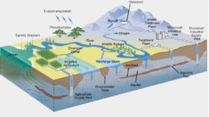 The basin setting is summarized in a hydrogeological conceptual model, which describes a basin’s hydrology, land use, geology, water quality, and aquifer structure. The hydrogeologic conceptual model must have both a narrative and graphical form. For more information, click here for the Hydrologic Groundwater Modeling page at the Groundwater Exchange.
Describe groundwater conditions
Current and historical and groundwater conditions in a basin must be developed using the best available science and must include information about groundwater elevation data, seawater intrusion, groundwater quality issues, land subsidence, interconnected surface waters, and groundwater dependent ecosystems.
Develop a water budget
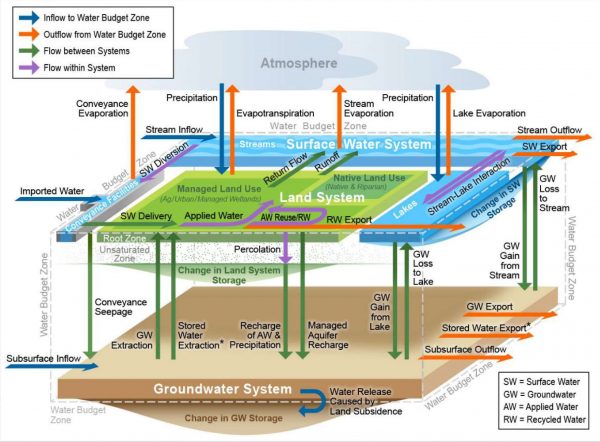 GSPs must include a water budget for the basin that provides an accounting and assessment of the total annual volume of groundwater and surface water entering and leaving the basin, including historical, current and projected water budget conditions, and the change in the volume of water stored. Water budget information must be reported in both tabular and graphical form. For more information on water budgets, visit the Groundwater Exchange’s Water Budget page.
Describe management areas
GSAs may choose to have one or more management areas in their basin. Management areas may define different minimum thresholds and be operated to different measurable objectives than the basin at large, provided that undesirable results are defined consistently throughout the basin. For more information on management areas, read GSP Regulations pertaining to management areas.
Step 4: Establish sustainable management criteria
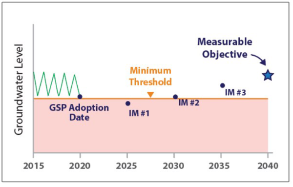
Achieving sustainable groundwater management under SGMA requires GSAs to establish a basin-wide sustainability goal, and avoid the six Undesirable Results (URs).
Developing minimum thresholds (the point below which URs occur) and measurable objectives are required components a sustainability goal.
Define the sustainability goal
Every basin subject to SGMA must develop a basin-wide sustainability goal that culminates in the absence of undesirable results within 20 years of GSP implementation. The sustainability goal must include a plan and measures to ensure it is met within 20 years of a plan’s implementation and maintained over the 50-year planning horizon.
Develop minimum thresholds
Minimum thresholds are set using a numeric value that represent a point in the basin that, if exceeded, may cause undesirable results. Development of minimum thresholds is required at the local level using information developed in the hydrogeologic conceptual model, the description of current and historical groundwater conditions, and the water budget.
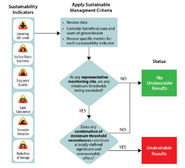 Plans must be developed to avoid the six undesirable results
Measurable objectives
Groundwater Sustainability Plans should set one or more measurable objective for each “sustainability indicator,” or each of the undesirable results. Measurable objectives should include interim milestones set at five-year intervals. The goal is eliminating undesirable results within 20 years of implementation of the plan (see below for definition).
Key publications
Draft Sustainable Management Criteria BMP (DWR)
[pdf-embedder url=”https://f0b.362.mwp.accessdomain.com/wp-content/uploads/2020/09/BMP-6-Sustainable-Management-Criteria-DRAFT_ay_19.pdf” title=”BMP 6 Sustainable Management Criteria DRAFT_ay_19″]Measuring What Matters Setting Measurable Objectives to Achieve Sustainable Groundwater Management in California
[pdf-embedder url=”https://f0b.362.mwp.accessdomain.com/wp-content/uploads/2020/09/measuring-what-matters-california-sustainable-groundwater-report.pdf”]GSP regulations pertaining to sustainable management criteria
[pdf-embedder url=”https://f0b.362.mwp.accessdomain.com/wp-content/uploads/2018/07/GSP-Regs-Art-5-Plan-Contents-Sub-3-Sust-Mgt-Criteria.pdf”]Step 5: Incorporating Climate Change
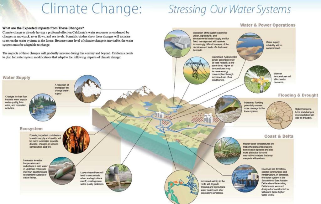 Climate change is already having a significant impact on water resources throughout the globe, resulting in more severe and prolonged droughts, increased flooding, changes in the timing and intensity of precipitation, sea level rise, and a host of other impacts. Scientists predict these impacts will become increasingly intense and less predictable under climate change.
To help GSAs anticipate and plan for these impacts, GSPs must include quantitative climate change analysis into their planning process. Specifically, water budgets must include projected hydrology, water demand, and surface water supply account for climate change (CCR §354.18(3)).
Key publications
Resource Guide: DWR-Provided Climate Change Data and Guidance for Use During Groundwater Sustainability Plan Development
The California Department of Water Resources (DWR) provides multiple resources related to climate change for Groundwater Sustainability Agencies (GSAs) to use during the development of Groundwater Sustainability Plans (GSPs). This document gives GSAs and other stakeholders a high-level overview of these climate change resources including datasets provided by DWR, tools for working with the DWR-provided datasets, and guidance for using DWR-provided data and tools in developing GSPs.
[pdf-embedder url=”https://f0b.362.mwp.accessdomain.com/wp-content/uploads/2020/09/Resource-Guide-Climate-Change-Guidance_v8_ay_19.pdf”]Guidance for Climate Change Data Use During Groundwater Sustainability Plan Development
The objective of this Guidance Document is to provide Groundwater Sustainability Agencies (GSAs) and other stakeholders with information regarding climate change datasets and related tools provided by the California Department of Water Resources (DWR) for use in developing Groundwater Sustainability Plans (GSPs). The datasets and methods are provided as technical assistance to GSAs to develop projected water budgets. The information provided in this Guidance Document describes the approach, development, application, and limitations of the DWR-provided climate change datasets. However, GSAs may choose not to use the DWR-provided Data, Tools and Guidance to develop projected water budgets.
[pdf-embedder url=”https://f0b.362.mwp.accessdomain.com/wp-content/uploads/2020/09/Climate-Change-Guidance_Final_ay_19.pdf”]SGMA Climate Change Resources
This dataset, located on the CNRA open data platform, includes processed climate change datasets related to climatology, hydrology, and water operations. The climatological data provided are change factors for precipitation and reference evapotranspiration gridded over the entire State. The hydrological data provided are projected stream inflows for major streams in the Central Valley, and streamflow change factors for areas outside of the Central Valley and smaller ungaged watersheds within the Central Valley. The water operations data provided are Central Valley reservoir outflows, diversions, and State Water Project (SWP) and Central Valley Project (CVP) water deliveries and select streamflow data. Most of the Central Valley inflows and all of the water operations data were simulated using the CalSim II model and produced for all projections.
Click here to access the resources on the CNRA open data platform.
The ArcGIS tools are developed to assist users in developing projected precipitation and evapotranspiration input files for models.
The Second Order Correction Tool is to assist users in correcting streamflow timing under projected conditions.
GSP regulation pertaining to water budgets and climate change
[pdf-embedder url=”https://f0b.362.mwp.accessdomain.com/wp-content/uploads/2018/08/GSP-Regs-Art-5-Plan-Contents-Sub-2-Basin-Setting-Water-Budget.pdf”]Step 6: Avoiding undesirable results
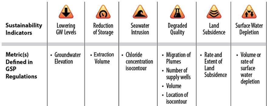
SGMA requires GSAs to develop and implement GSPs to avoid the six undesirable results listed below:
Step 7: Define projects and actions
Most Groundwater Sustainability Agencies will need to increase supply, manage demand, or do both to achieve sustainable groundwater management under SGMA.
Step 8: Monitoring and data management
Groundwater monitoring is at the heart of the Sustainable Groundwater Management Act (SGMA). Monitoring networks provide the foundation for developing an understanding of current conditions in the basin and how they are changing through time. Under SGMA, Groundwater Sustainability Agency (GSA) must develop a groundwater monitoring network that “promotes the collection of data of sufficient quality, frequency, and distribution to characterize groundwater and related surface water conditions in the basin…”
Each Groundwater Sustainability Plan (GSP) must include a description of the monitoring network objectives for the basin, including how the network will be developed and implement to ensure evaluate progress toward the basin’s sustainability goal.
To be compliant with SGMA, monitoring networks must be able to demonstrate progress toward achieving the measurable objectives, monitor impacts to beneficial users of groundwater, monitor changes in groundwater conditions relative to measurable objectives and minimum thresholds, and quantify changes in water budget components. Additionally, the networks must collect sufficient data to demonstrate short-term, seasonal, and long-term trends in groundwater and related surface conditions.
Monitoring networks must monitor for all six sustainability criteria unless the GSA has demonstrated that undesirable results for the sustainability criteria are unlikely to occur. GSPs must include the quantitative values for minimum threshold, measurable objectives, and interim milestones for each sustainability criteria, that will be measured at each monitoring site.
FOR MORE INFORMATION: USGS webpage on monitoring groundwater levels
Key publications
BMP 1: Monitoring Protocols Standards and Sites
[pdf-embedder url=”https://f0b.362.mwp.accessdomain.com/wp-content/uploads/2020/09/BMP-1-Monitoring-Protocols-Standards-and-Sites_ay_19.pdf” title=”BMP 1 Monitoring Protocols Standards and Sites_ay_19″]
BMP 2: Monitoring Networks and Identification of Data Gaps
[pdf-embedder url=”https://f0b.362.mwp.accessdomain.com/wp-content/uploads/2020/09/BMP-2-Monitoring-Networks-and-Identification-of-Data-Gaps_ay_19.pdf” title=”BMP 2 Monitoring Networks and Identification of Data Gaps_ay_19″]GSP Regulation requirements for monitoring networks
[pdf-embedder url=”https://f0b.362.mwp.accessdomain.com/wp-content/uploads/2018/07/GSP-Regs-Art-5-Plan-Contents-Sub-4-Monitoring-Networks.pdf”]Step 9: Interbasin Agreements and Coordination Agreements
Interbasin Agreements, agreements between adjacent basins, are not required under SGMA. Two or more GSAs may enter into an Interbasin Agreement to establish compatible goals and understandings regarding fundamental elements of each GSP.
Interbasin agreements can be used where a groundwater hydraulic connection exists between basins to share technical information and provide a process for resolving conflicts. Interbasin agreements can also be included in a GSP to support findings that implementing a basin’s GSP will not adversely affect an adjacent basin’s ability to implement its GSP.
Click here to read more about Interagency Agreements.
In basins with multiple GSPs, a single Coordination Agreement must be submitted with the GSPs to DWR. The coordination agreement ensures that GSPs are developed and implemented using consistent data, methodologies, and objectives.
The Coordination Agreement must demonstrate how multiple GSPs will jointly achieve the basin’s sustainability goal. Additionally, it must include the responsibilities of each GSA in the basin; the procedures for exchanging information and resolving conflicts; and a description of the data, methodologies, and assumptions used in GSP development.
For more on coordination agreements, click here.
Step 10: Submit the completed plan to the Department of Water Resources
When you have finished your Groundwater Sustainability Plan (GSP), it must then be submitted to the Department of Water Resources.
All groundwater basins that are designated high or medium priority must submit their completed GSPs by January 31, 2022. Groundwater basins designated as critically overdrafted submitted their completed GSPs in January of 2020.
Key resources
Checklist for GSP Submittal
[pdf-embedder url=”https://f0b.362.mwp.accessdomain.com/wp-content/uploads/2020/08/Preparation-Checklist-for-GSP-Submittal.pdf” title=”Preparation Checklist for GSP Submittal”]DWR has developed three guidance documents, available below, to assist GSAs in submitting their adopted GSPs to the GSP Reporting System and identifying the GSP monitoring network in the Monitoring Network Module.
The DWR video of the Groundwater Sustainability Plan (GSP) Reporting System Workshop webcast will assist those submitting GSPs. It includes information on the updated SGMA Portal, provides an overview of the new online GSP Reporting System and Monitoring Network Module, and answers questions submitted during the live webcast.
How to submit comments on GSPs submitted to DWR
GSPs submitted to DWR are available online on DWR’s SGMA Portal. DWR will post the plans within 20 days of submittal for public viewing. DWR’s posting starts a 75-day public comment period. Public comments are welcomed and encouraged – a SGMA Portal account is not necessary.
More information about how to comment on a plan can be found below:
Once submitted, the Department has two years to review the plan. A GSP may be deemed inadequate if the Department, in consultation with the State Board, determines that the GSP is inadequate or if it is not being implemented in a manner that will likely achieve the sustainability goal. If it is found inadequate, GSAs have one year to address the deficiencies or the State Board may develop an interim plan for the basin.
For more information on State Water Board intervention, click here.


